YogLabs

YogLabs AI Research Foundation, a non-profit research laboratory in Jaipur, India, is dedicated to advancing scientific research and education through interdisciplinary collaboration and AI-based tools. As a Section 8 company, it connects academia, government, and industry to solve complex problems and promote research-focused education. The foundation focuses on India-centric data, developing high-quality solutions and enhancing scientific understanding across domains like authentic news dissemination, misinformation reduction, GIS, agriculture, climate change, urban computing, and cultural studies. With the motto "AI-Based Union/Synergy," YogLabs aims to harmonize relationships between entities using AI. The expert team, including Dr. Ankit Sharma (director at YogLabs), Lokendra PS Chauhan (research collaborator at YogLabs and co-founder of QenLabs), and Prof. Jaideep Srivastava (professor at the University of Minnesota, USA), brings extensive experience in AI, data science, and GIS. YogLabs also excels in technology transfer, from proof-of-concept stages to machine learning pipeline development and productization.

MapYog: Intelligent Spatiotemporal Map Data Explorer

The MapYog project aims to simplify exploratory data analysis of complex spatiotemporal phenomena such as air pollution, urban heat islands, weather conditions, and other variables. The primary challenge lies in the lack of tools that can seamlessly fuse data from diverse sources and types for visual analysis, especially for users without coding skills. This project addresses this gap by building a tool that facilitates exploratory visual analysis. The tool preprocesses and combines data from various resolutions and modalities, harmonizing them to a uniform resolution suitable for neighborhood or building-level visualization. A backend machine learning model will generate fine-scale predictions based on sparsely distributed observations of particulate matter, heat levels, and relevant environmental factors. Additionally, the system will enable the integration of datasets like socio-economic indicators in map-based visualizations, offering a comprehensive understanding of critical urban phenomena.

NakshaYog: AI-Driven Hyperlocal Map Curation

The NakshaYog project focuses on using AI to curate local and hyperlocal geographical data and maps. It aims to automate the extraction of local and hyperlocal boundaries, cadastral mapping with various granularities, and the extraction of information from noisy scanned images of recent and historical maps. While region and city-level boundaries are accessible, information on hyperlocal boundaries is scarce. Existing geocoding services offer only rectangular bounding boxes, and proprietary data services like Google Maps do not provide boundaries through their APIs. This project leverages publicly available cadastral maps from government and authentic sources. The main challenges involve digitizing maps and extracting boundary information from noisy, manually curated scanned images, especially older maps. Geo-referencing these images is complex, but the project seeks to extract hyperlocal map boundaries and overlay them on global maps like OpenStreetMap (OSM). This effort supports the smart city movement in India and contributes to the urban digital twin initiative by digitizing non-digital cadastral map data. It also impacts legal and urban planning by providing digitized legal boundaries, aiding infrastructure planning, and identifying non-conforming issues for authorities.

NewsYog: Hyperlocal News Personalization

The Hyperlocal News Personalization project aims to enhance the Geo-personalization of news content by extracting geographically localized information from mass media sources. In today's world, the internet and social media platforms facilitate rapid information propagation and personalization. However, trustworthy news content is still predominantly produced by a few major newspapers and channels, which tend to offer generalized mass-media content rather than personalized information. The project explores the hypothesis that newsworthy content is inherently local to individuals and investigates the potential to mine geographically localized content from these mass media sources. By doing so, the project aims to provide hyperlocal e-governance by delivering hyperlocal content. Advanced NLP and computer vision-based multimodal methods are employed to extract information from complex extraction points (EPs) such as e-paper PDFs, websites, and documents. Additionally, advanced GeoAI and data-mining techniques are utilized to mine hyper-localized content and facilitate powerful geo-localization/geocoding of the extracted news and information.

RasYog: Fashion AI for Indian Aesthetics

Applying AI on Indian Consumer data of Fashion Brands for building scientific understanding for Indian Aesthetics and helping better decision making for the Fashion Industry. A mutually beneficial partnership between the research community and industry based on data-driven AI research. In the process also rejuvenating the cultural awareness as well as scientific research in the field of Indian Philosophies for Aesthetics (Ras).
The first version of RasYog provides a comprehensive taxonomic and sales analysis of fashion store data. Leveraging powerful visual analytics techniques to easily analyze and organize your data into various categories of products, brands and pricing based on similarities and differences. Also allows for dynamic temporal analytics of sales data to provide insights into both product popularity and availability.

Description of the image

Dr. Ankit Sharma

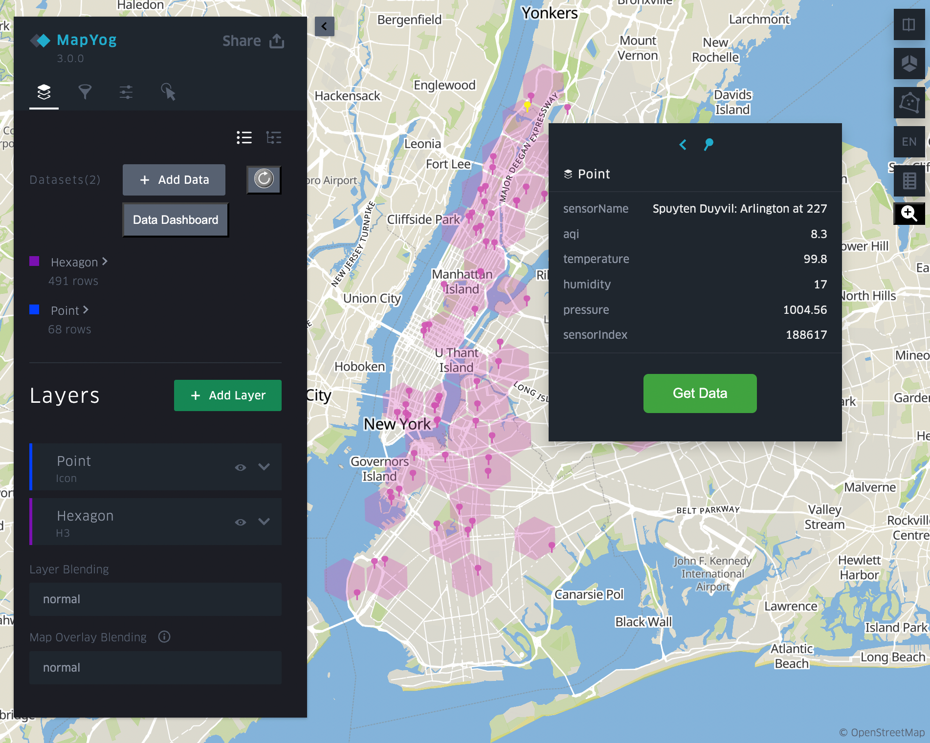
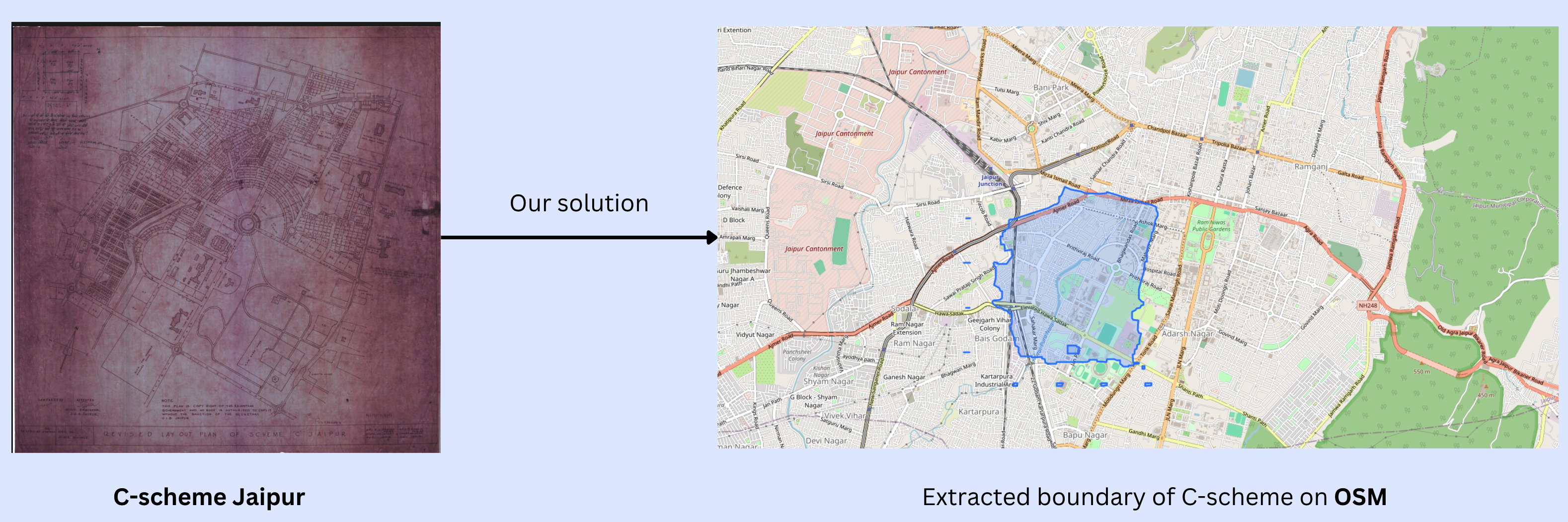
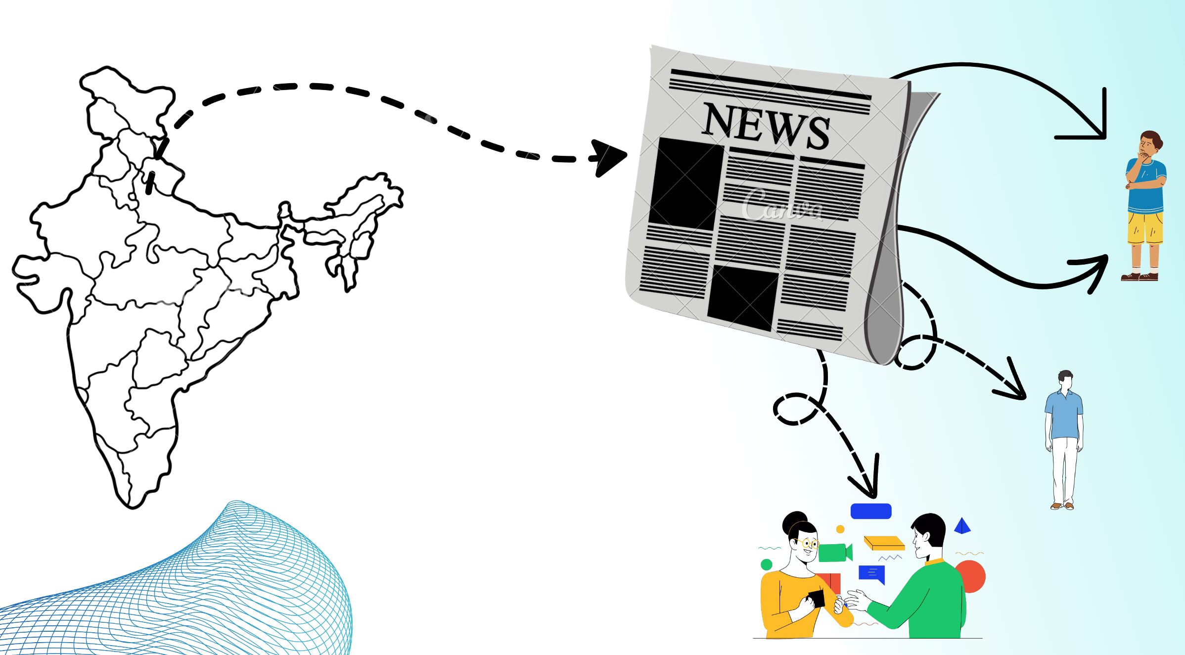
Dr. Ankit Sharma is an accomplished AI and data science expert with a diverse range of academic and industry experiences. He completed his MS and Ph.D. in Computer Science at the University of Minnesota, focusing on machine learning models for hypergraphs and developing the Minnesota Engine for Hypergraph Analytics (MESH). His work at FastBridge, an education data-mining/AI startup, involved creating data mining pipelines for educational psychology models. Ankit's internships at the Army Research Lab (ARL, Maryland, USA) and Qatar Computing Research Institute (QCRI, an AI research lab in Doha, Qatar) saw him applying AI models to analyze team behavior and urban computing problems. At Contata Solutions, a data analytics firm in Minneapolis, USA, he specialized in knowledge graph-based language models. As a faculty member at IIIT Kota from 2021 to 2023, Ankit taught courses such as Machine Learning and Data Mining, emphasizing project-based learning and mentoring students on projects like generative models for Indian classical music. He was also a co-Principal Investigator on a Rajasthan government grant focused on AI in education. Ankit's consulting roles with QenLabs (a geospatial and GeoAI-focused company in Minneapolis, USA) and Melio (a bioinformatics startup research lab in San Jose, USA), as well as his work at YogLabs, which he founded, on projects like NewsYog (hyperlocal news personalization) and NakshaYog (AI-driven map curation), highlight his commitment to advancing AI applications for societal benefit and establishing himself as a leader in the field.

Lokendra Chauhan

Lokendra Chauhan is a seasoned expert in AI and geospatial technology, leveraging his extensive experience as the founder of Qen Labs Inc. to drive innovation in AI applications that utilize satellite imagery to advance the United Nations' Sustainable Development Goals. His expertise spans developing AI products, such as those funded by SBIR projects with the Department of Energy, focusing on high-resolution spatiotemporal predictions from low-resolution data collected via edge devices. Lokendra's work in software product development has a global footprint, with successful projects in the US, India, and Qatar, including human activity monitoring using wearable technology. He is recognized for his leadership in the GeoAI domain, co-chairing the GeoAI Domain Working Group at the Open Geospatial Consortium and curating GeoAI challenges for the AIForGood initiative at the UN's ITU. As a prolific author and thought leader, he has contributed significant insights through industry reports and academic papers, emphasizing the transformative impact of GeoAI. His role on the Business Advisory Group of the University of Minnesota's Technology Commercialization Office further underscores his commitment to bridging the gap between research and practical application. Lokendra's combined expertise in AI development, product management, and business strategy positions him as a pivotal figure in advancing geospatial and AI technologies on a global scale.

Get in touch